East 4th Street
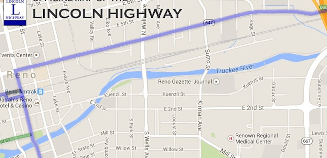
This north downtown Reno neighborhood blossomed with the first transcontinental roadway and continues to attract entrepreneurs today. A budding brewery culture, creative businesses expressing the values of burning man, public transportation hubs, and news outlets continue the tradition of first-wave economic movement.
East 4th Street Map
East 4th Street Parcel Search
Note: these are not lists of properties available for sale. The spreadsheets help you research all land in this neighborhood.
The CSV files download from the Washoe County Assesor's office. They provide detailed information about how each piece of land is used and who owns it.
Multi-Family
- Land Use: Multifamily - Low Density -- Site Values / SF / Unit (LUC 13, 30 thru 33)
- MAP abbreviation: AHEK
- CSV spreadsheet
Diamonds
- Land Use: Casino -- Square Foot Values
- MAP abbreviation: AHHS
- CSV spreadsheet
Government
- Land Use: Centrally Assessed
- MAP abbreviation: AHYY
- CSV spreadsheet
Commercial
- Land Use: Commercial - General -- Square Foot Values
- MAP abbreviation: AHBQ
- CSV spreadsheet
Wells & 6th St. SFRs
- Land Use: Single Family Residence 6,000 - 9,000 Sf Zoning -- Site Values
- MAP abbreviation: AHFC
- CSV spreadsheet
Spokane Plaza, Office Condos
- Land Use: Office Condos -- Square Foot / Site Values
- MAP abbreviation: AHIP
- CSV spreadsheet
Industrial
- Land Use: Industrial -- Square Foot Values
- MAP abbreviation: AHCU
- CSV spreadsheet
Elko Ave. Condos
- Land Use: Condos / Townhouse - Site Values
- MAP abbreviation: AHGA
- CSV spreadsheet
Common Area/Token Values
- Land Use: Token Values -- Common Area / Splinters / Unbuildable
- MAP abbreviation: AHVV
- CSV spreadsheet
These CSV files download from Washoe County Public Records. Please see instructions, disclaimers, and always verify information before making a decision DISCLAIMERS
Downtown Reno Neighborhoods
Current Neighborhood Data
The csv links on these pages are out of date. Please look up the four digit codes on this page to access the ownership spreadsheets:
Map of all Neighborhoods

Seize no power.
Change everything.
Professionals and volunteers team up with groups and people to collaborate on community building projects